Ontario field guide
Trees of Ontario, region by region
Ontario has four forest regions, from the Hudson Bay Lowlands to the Carolinian woodlots of the far south. Each has a short list of trees worth learning first.
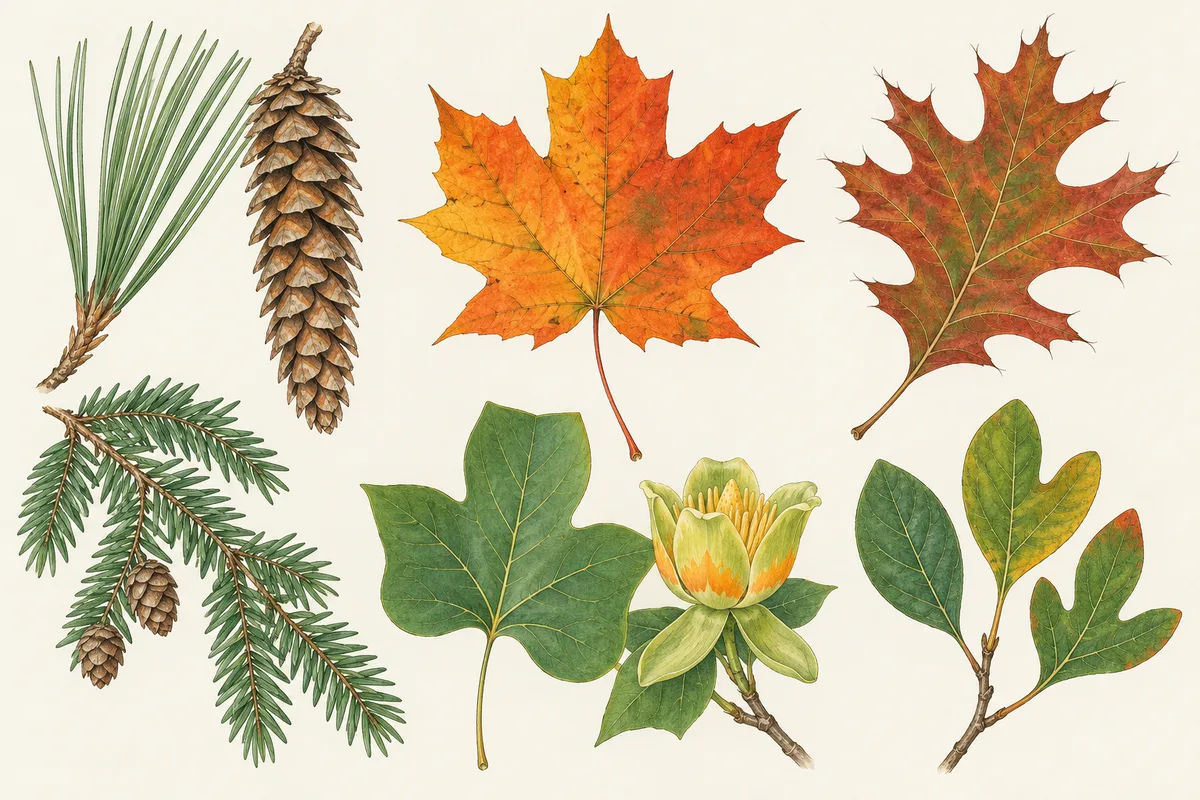
In short
The trees of Ontario sort into four forest regions. The Hudson Bay Lowlands carry stunted black spruce and tamarack; the Boreal adds jack pine, balsam fir, poplar and white birch; the Great Lakes–St. Lawrence region has sugar maple, red oak, yellow birch and white and red pine; the southern Deciduous (Carolinian) region adds black walnut, tulip tree and sassafras. Black spruce is Ontario's most common tree.
- Ontario's ministry ranks black spruce, poplar and jack pine as the province's three most common trees, and sugar maple fifth.
- The eastern white pine has been Ontario's official tree since May 1, 1984: soft needles in bundles of five.
- The Deciduous forest region covers about 3% of Ontario but has the greatest tree diversity in the province.
Ontario's forests run from bog and tundra on Hudson Bay to scattered hardwood woodlots on Lake Erie, and the trees change with them. The Ontario government divides the province into four forest regions. This guide follows them from north to south, names the trees most worth learning in each, and gives the province's own list of its most common trees. Never eat a berry, nut, seed or pod on the strength of a web page or an app; check with a local expert.
Ontario's four forest regions at a glance
The figures below are from the Government of Ontario's Forest regions page (updated 23 March 2026).
| Forest region | Where | Share of Ontario | Trees the province names |
|---|---|---|---|
| Hudson Bay Lowlands | Far north | 26.3% | Stunted tamarack and black spruce; white birch, dwarf birch, willow |
| Boreal | Northern Ontario | 50% | Black and white spruce, jack pine, balsam fir, tamarack, eastern white cedar, poplar, white birch |
| Great Lakes–St. Lawrence | Central and southern Ontario, and west of Lake Superior | 20% | White and red pine, hemlock, white cedar, yellow birch, sugar and red maple, basswood, red oak |
| Deciduous (Carolinian) | Southernmost Ontario | 3% | Most Great Lakes–St. Lawrence trees plus black walnut, butternut, tulip tree, black gum, oaks, hickories, sassafras, redbud |
Two habits help everywhere. First, decide conifer or broadleaf. Second, for broadleaf trees, check whether leaves sit opposite each other on the twig: in an Ontario forest, opposite leaves usually mean a maple or an ash. Then use the region to narrow the candidates.
Hudson Bay Lowlands and the Boreal forest
The Hudson Bay Lowlands hold, in the province's words, one of the largest expanses of wetland in the world, and only about a quarter of the region has forest cover. Trees are mostly stunted tamarack and black spruce along riverbanks and on better-drained ground. Tamarack is the conifer that turns gold and drops its needles in autumn; the tamarack profile explains its soft needle tufts.
The Boreal forest is Ontario's largest region, about 50 million hectares and two-thirds of the province's forest. Learn these first, with clues from Natural Resources Canada's factsheets and the Ontario ministry:
- Black spruce (Picea mariana): short, dull greyish-green needles 8 to 15 mm on hairy twigs, and small rounded cones clustered near the top of the tree. Ontario describes it on wet or organic sites, often in large, nearly pure stands.
- Jack pine (Pinus banksiana): short, sharp, slightly curved needles in pairs, two to four centimetres long, and curved cones that open after a forest fire (Ontario ministry). It favours sandy or rocky sites in the north.
- Balsam fir (Abies balsamea): flat, fragrant needles and sticky resin blisters on the trunk; often grows in clumps under other trees.
- Poplar (Populus): Ontario's ministry groups trembling aspen, largetooth aspen and balsam poplar. Trembling aspen has nearly round leaves on a flattened stalk that make the crown flutter. See the poplar guide.
- White birch (Betula papyrifera): smooth white bark that peels like paper.
- Eastern white cedar (Thuja occidentalis): flat, fan-shaped sprays of scale leaves; Ontario notes it prefers swampy areas but also grows on rocky uplands.
Great Lakes–St. Lawrence forest
This is Ontario's second-largest forest region, about 20 million hectares stretching along the St. Lawrence to Lake Huron and west of Lake Superior along the Minnesota border. It is dominated by hardwoods, and much of it is uneven-aged, with young and old trees in the same stand.
- Eastern white pine (Pinus strobus), Ontario's official tree: soft needles in bundles of five, six to twelve centimetres long by the ministry's figures, and long, hanging cones. Canadian Heritage's Ontario page gives May 1, 1984 as the adoption date and calls it the province's tallest tree, able to live more than 250 years.
- Red pine (Pinus resinosa): long, sharp, dark green needles in pairs, 10 to 16 cm. To separate it from white pine and jack pine, see red pine vs white pine.
- Sugar maple (Acer saccharum): five-lobed leaves with rounded notches; the leaf on the Canadian flag, as the ministry puts it. Red maple (A. rubrum) has V-shaped notches and toothed edges; red maple vs sugar maple compares them.
- Yellow birch (Betula alleghaniensis): silvery grey to yellowish bark in thin curling shreds, on cool, moist upland sites.
- Eastern hemlock (Tsuga canadensis): short flat needles in two rows with white lines beneath, on cool moist soils near water, often with yellow birch and maple.
- Red oak (Quercus rubra): leaves with bristle-tipped lobes. Ontario's ministry says red oak is the most common of its native oaks, ahead of white and black oak.
The Deciduous (Carolinian) forest in the far south
The Deciduous forest region, also called the Carolinian zone, covers almost 3 million hectares, about 3% of Ontario. The province calls it the region with the greatest tree diversity and the lowest proportion of forest: farms and cities cover most of it, and forest covers about 10%. The Tree Atlas species pages give these ranges and clues:
- Tulip tree (Liriodendron tulipifera): leaves 7 to 12 cm, flat across the top with four pointed lobes; yellow-green and orange tulip-shaped flowers in spring; 25 to 35 m tall. Native only on the south shore of Lake Huron, the north shore of Lake Erie and the Niagara Peninsula.
- Sassafras (Sassafras albidum): leaves with no lobes, two lobes or three lobes on the same tree, smooth-edged and blunt-tipped. Uncommon, it grows in the Carolinian zone north to about Toronto, often in colonies.
- Kentucky coffeetree (Gymnocladus dioicus): doubly compound leaves whose central stalk is often mistaken for a twig, and hard, leathery pods 12 to 20 cm long that hang on through winter. It grows naturally only in Southwestern Ontario and is a species at risk in the province, though it is widely planted.
- Black walnut (Juglans nigra): compound leaves of 14 to 22 leaflets, the end leaflets smaller than the rest, and dark, thickly ridged bark. Common in moist, low ground in Southwestern Ontario and often planted farther north. The walnut guide separates it from butternut.
- Sycamore (Platanus occidentalis): large, maple-like leaves and patchwork bark flaking to show white, green and cream. Scattered in Southwestern Ontario to the Toronto area, with outlying pockets as far north as Collingwood–Thornbury. The sycamore page covers it and the planted London plane.
The province also lists butternut, black gum, hickories, many oaks, redbud and cucumber tree, Ontario's native magnolia, in this region.
The most common trees in Ontario
The Ontario Ministry of Natural Resources' Common trees page in Forest resources of Ontario 2021 (updated 26 June 2025) states that black spruce is Ontario's most common tree, poplar the second, jack pine the third and sugar maple the fifth. The page does not name the measure behind that ranking. Its "total area as lead species" figures for the managed forest zone match it, so we rank by that measure below. Shares are our arithmetic against the 36.6 million ha total in the same page's 2021 lead-species table.
| Rank | Tree | Area as lead species (ha) | Share | How to recognize it |
|---|---|---|---|---|
| 1 | Black spruce | 14,848,443 | 40.6% | Short, dull needles on hairy twigs |
| 2 | Poplar (aspens, balsam poplar) | 5,798,466 | 15.8% | Leaves on long stalks that flutter |
| 3 | Jack pine | 5,515,636 | 15.1% | Pairs of 2–4 cm needles, curved cones |
| 4 | White birch | 3,163,344 | 8.6% | White bark peeling like paper |
| 5 | Sugar maple | 1,862,280 | 5.1% | Opposite leaves, U-shaped notches |
| 6 | Balsam fir | 1,071,974 | 2.9% | Flat fragrant needles, resin blisters |
| 7 | White pine | 977,527 | 2.7% | Soft needles in fives |
| 8 | White cedar | 744,385 | 2.0% | Flat sprays of scale leaves |
| 9 | Red maple | 493,498 | 1.3% | V-shaped notches, red buds |
| 10 | Larch (tamarack) | 487,548 | 1.3% | Needle tufts that drop in autumn |
Ranked by the area that contains each species instead, white birch (17.1 million ha) and poplar (16.6 million ha) come ahead of jack pine, so the order depends on the measure. For the national picture, see the most common trees in Canada.
Field guides and a photo app for Ontario trees
The Ontario government's Tree Atlas, published in 2021 and updated 5 May 2026 when we read it, lists 79 native species or species groups. Pick a point on its map or one of five regions (Northwest, Northeast, South Central, Southwest, Southeast) and the list narrows to the native trees of that area, each with a page on identification and growing conditions. Natural Resources Canada's factsheets add measurements and range maps, and the Canada hub lists every provincial tree.
When the leaves are out of reach, Tree Identifier names a tree from one photo of a leaf, needle bundle, bark or fruit, with a follow-up chat for questions such as "is this a red or a white pine?". It shows no confidence score and no look-alike list, so confirm with the clues above. Its Tree Map keeps each located find, useful for coming back to a Carolinian tree when it flowers.
What a photo can't settle
- Ontario's most-common ranking covers the managed forest zone, not the far north or the cities, so it says little about the trees on a Toronto or Ottawa street.
- Many Carolinian trees, such as black walnut, are planted well north of their natural range, so a tree's location doesn't confirm or rule out a species.
- Hybrid maples and planted cultivars in towns can show mixed features that neither a key nor a photo app settles.
Questions people ask
What are the most common trees in Ontario?
Ontario's Forest resources of Ontario 2021 report names black spruce the most common tree, poplar second, jack pine third and sugar maple fifth. By area as lead species in the managed forest zone, white birch sits between jack pine and sugar maple, followed by balsam fir and white pine.
What is Ontario's provincial tree?
The eastern white pine (Pinus strobus), adopted on May 1, 1984. Canadian Heritage calls it the province's tallest tree, able to live more than 250 years. Look for soft needles in bundles of five; Ontario's ministry gives them as six to twelve centimetres long.
What trees grow only in southern Ontario?
The Carolinian trees of the Deciduous forest region. Ontario's Tree Atlas limits tulip tree to the Lake Huron south shore, the Lake Erie north shore and the Niagara Peninsula, Kentucky coffeetree to Southwestern Ontario, and sassafras to the Carolinian zone north to about Toronto.
Is there a free Ontario tree identification guide?
The Ontario government's Tree Atlas, read on 21 October 2026, lists the province's native trees with a page for each species and a map that filters the list by where you live. Natural Resources Canada's free factsheets add measurements and range maps.
What trees grow in northern Ontario?
Mostly the Boreal list: black and white spruce, jack pine, balsam fir, tamarack and eastern white cedar among the conifers, poplar and white birch among the broadleaf trees. In the Hudson Bay Lowlands farther north, stunted black spruce and tamarack grow along rivers and on better-drained ground.
Sources
- Forest regions — Government of Ontario (ontario.ca)
- Common trees, Forest resources of Ontario 2021 — Ontario Ministry of Natural Resources (ontario.ca)
- Tree Atlas — Ontario Ministry of Natural Resources (ontario.ca)
- Ontario: provincial symbols — Canadian Heritage, Government of Canada
- Trees, insects and diseases of Canada's forests: tree factsheets — Natural Resources Canada, Canadian Forest Service
Keep reading
- Canada field guideTree identification in Canada, region by region
- Canada by the numbersThe most common trees in Canada, ranked by forest area
- Tree comparisonRed pine vs white pine: how to tell them apart, with jack pine
- Tree comparisonRed maple vs sugar maple: how to tell them apart
- Tree profileWalnut trees (Juglans): how to identify them